Rudd Company
SkimStone Bonding Primer
SkimStone Bonding Primer allows SkimStone decorative finishes to be used on non-porous substrates such as plastic laminate or ceramic tile.
The Bonding Primer is specially formulated to enhance inter-coat adhesion and may also be used on previously sealed or painted concrete floors, where removal by grinding or shot blasting is not possible.
SkimStone is a unique decorative finishing system that transforms ordinary concrete into a one-of-a-kind element of design.
A simple three-coat application provides a beautiful organic textured look suitable for both interior and exterior use, in residential or commercial spaces.
The versatile SkimStone system provides unlimited color options, easy-to-achieve special effects, and water cleanup.
For more information, visit the Skimstone Web site or call (800) 444-7833.
Saturday, March 8, 2008
Thursday, March 6, 2008
A Trip from Germany in the 1700's

Historical records tell us that ANDREAS HITE emigrated to Rotterdam, Holland, aboard the ship "Saint Andrew Galley" stopping for supplies in Cowes, England, enroute to Philadelphia, Pennsylvania September 26, 1737.
Rotterdam was the Dutch seaport through which he traveled in his travels to come to America, with his wife Magdalena.
Europe was experiencing a tremendously violent upheaval as the axis of power shifted the nation from the vice grip of religious control which for centuries held the nation within the iron fist of religious suppression. Zwingli and his disciples became the first to renounce allegiance to Rome in 1520, and within 50 years 40 percent of the inhabitants of Europe observed a "Reformed Theology." The Swiss COnfederation embraced the new faith, and the cantons of Zurich, Berne, Basel and Shaffhausen were Protestant. But the Catholic church exercized resistance, with the 30 Years War a tumultuous and difficult era for the Palatinate region, and other areas vitally impacted by it. The war was primarily a religious war, which included the witchhunts from 1622-28. Witches were said to communicate with the devil and were blamed for many of the hardships and illnesses.
In 1688, King Louis XV of France sent troops into the Palatinate to secure it for France. Again in 1702 the people of the Palatinate endured the hardship of war, with thoughts of abandoning homes and farms in the Palatinate looming largely as their major hope for the future, as the war dragged on.
During winter of 1708-1709 people huddled around their fires to keep warm, with frequent discussions of immigration.
Difficult questions were asked: What about the travel documents? Which family members would go? What month to leave in? How would they obtain the necessary finances? What possessions would they take with them? What ship would they travel on?
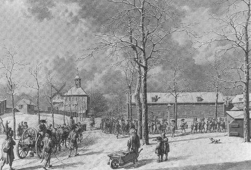
As they faced the difficulties, and formulated travel plans, France's King Louis XIV invaded their land, ravaging especially the towns in the Lower Palatinate, forcing them to flee in their small boats, called scows on the Rhine River, to Rotterdam. The trip to Holland was not an easy journey, but took on an average between four to six weeks.
Embarking on their journey, Palatine refugees ran the risk of being discovered by the authorities, who demanded bribes to allow them to pass unhindered or threatened to force their return. If they encountered a sympathizer, they may be given food, clothing and money. Upon reaching Holland, the family encamped outside the city of Rotterdam in a reed covered shack.
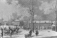 There in this "city of refuge" called Rotterdam, the Hites booked passage aboard a sailing ship to America. Either the family made it to the Netherlands, lived and worked here to earn their passage, or they fled, with a good deal of hardship along the way, since money would have been hard to come by, unless providencially saved ahead of time, and with the economic situation, this would have been hard to do.
Most of the German immigrants sailed to Pennsylvania from Dutch ports, such as Rotterdam and Amsterdam in Holland, after coming down the Rhine River from Germany. Thus, English speaking people may have confused them as being Dutch because the ship lists reported they embarked for the new world from Dutch ports. Thus, some people may have incorrectly thought these Palatine Germans and other German speaking people were Dutch.
People referred to as "Pennsylvania Dutch" were ethnic Germans that immigrated to Pennsylvania, with most coming to America between between 1730 and 1760. They weren't Dutch in the modern sense of Holland Dutch; but Germans who fled the Rhineland Palatinate in times of persecution and finding refuge in Switzerland, or Alsace which is now in France, they traveled to America via Holland or the Netherlands.
If their economic situation as refugees necessitated them living and working in Holland, their names on immigration documents may reflect this Dutch heritage.
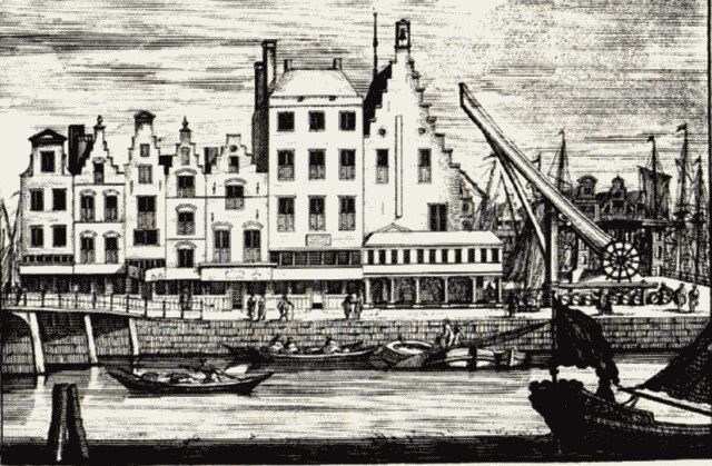
Rotterdam started out as a small village on the River Rotte. By 1250, the river mouth was closed off by dams; rising sea levels meant that too much salt water was able to penetrate inland. However, these dams hampered shipping traffic. This made it necessary to carry cargo over the dam, loading it from one ship to another. The dam therefore turned out to be an outstanding location for the trading of cargo. Thanks to the herring fishing industry, the village grew into a city.
Around 1600, the port was able to accommodate as many as 100 herring ships. Rotterdam developed into a mercantile port. Merchant ships sailed from Rotterdam to South America and the Dutch East Indies and back. Ships would anchor right in the heart of the city to among other things discharge tobacco and spices. These products were stored in the warehouses on the quays.
Those people living in America who describe themselves as Black Dutch or Black German, are a particular of a ethnicity, that is not always fully understood. Schwarze Deutsche or Black Germans, found along the Danube River in Austria and Germany, in the Black Forest and, to a lesser extent, along the Rhine River, have dark hair and eyes, unlike the fairer people both north and south of them. Their descendants in America may be called either Black Dutch or Black German.
The Black Forest, or Schwarzwald, is a section of Southwestern Germany that borders on Switzerland on the south, on the Neckar River to the East and on France to the West. The Northern gate to the Black Forest is Pforzheim.
The Black Forest is named for the beautiful mountain landscape with its dense population of pine trees. It is a region of incomparably unspoiled nature with its forests, mountains and meadows.
The Black Forest is known for its half-timber houses many of them 300 years old. The craftsmen of the area are well known around the world for their cuckoo clocks and the Christmas season is never complete without a nutcracker from this region. Castles, vineyards and orchards dot the hillsides.
Dutch is the English form of Deutsch in German or Duits in Dutch (Nederlands). It has come to mean the people of the Netherlands only in English recently, but it originally meant all speakers of German in the broadest sense. This includes the entire German sub-branch of the Germanic Branch of the Indo-European Language Family.
The other sub-branches are the Anglo-Friesian (English, Scots and Friesian) and the Nordic (Swedish, Dano-Norwegian [Danish, Riksmal {Boksmal} and Landsmal {Nynorsk}], Icelandic, and Faeroese [Faroese]). There are many dialects and languages in the German sub-branch, divided into High German and Low German. The forms of High German are German [High Saxon, Alemanni, High Frankish (Franconian), Swabian, Bavarian, Austrian, Luxembourgese, Alsatian, Styrian], Swiss German, and Yiddish. Low German includes Dutch, Flemish, Afrikaans [South African Dutch], Hanoverian [Low Frankish {Franconian}], Hessian, Low Saxon [Brandenburgian], Holsteiner, Pomeranian and Prussian. The Frankish area includes Rheinland-Pfalz and Hanover, with the area south of Aachen [Charlemagne's capital], centered on Frankfurt, speaking a High German dialect, and the area from Aachen north, centered on Essen, speaking a Low German dialect. The Pennsylvania Dutch are Low Germans from Germany, not Dutch from Netherlands. The Pennsylvania German language resembles most closely the dialects of the German Palatinate.
However, Pennsylvania German speakers came from various parts of the southwest German speaking corner including Swabia, Württemberg, Alsace, and Switzerland. In the first generations after the settlers came over there is believed to have been a merging of the dialects. The language which resulted resembled most the Palatinate German.
The term "Pennsylvania Dutch" is a result of English-speaking people mispronouncing the German word "Deutsch." Yet another theory is that most of them, came here on ships which embarked from the port of Rotterdam, at the mouth of the Rhine, which is in Holland.
Passengers lists submitted by the ship's captains to the Philadelphia immigration authorities, used the word "Pfaltzers", which means from the Pfalz, the Palatinate, in what is now the modern German state of Rhineland-Pfalz.
http://www.angelfire.com/journal2/skylarks/page14.html
Rotterdam was the Dutch seaport through which he traveled in his travels to come to America, with his wife Magdalena.
Europe was experiencing a tremendously violent upheaval as the axis of power shifted the nation from the vice grip of religious control which for centuries held the nation within the iron fist of religious suppression. Zwingli and his disciples became the first to renounce allegiance to Rome in 1520, and within 50 years 40 percent of the inhabitants of Europe observed a "Reformed Theology." The Swiss COnfederation embraced the new faith, and the cantons of Zurich, Berne, Basel and Shaffhausen were Protestant. But the Catholic church exercized resistance, with the 30 Years War a tumultuous and difficult era for the Palatinate region, and other areas vitally impacted by it. The war was primarily a religious war, which included the witchhunts from 1622-28. Witches were said to communicate with the devil and were blamed for many of the hardships and illnesses.
In 1688, King Louis XV of France sent troops into the Palatinate to secure it for France. Again in 1702 the people of the Palatinate endured the hardship of war, with thoughts of abandoning homes and farms in the Palatinate looming largely as their major hope for the future, as the war dragged on.
During winter of 1708-1709 people huddled around their fires to keep warm, with frequent discussions of immigration.
Difficult questions were asked: What about the travel documents? Which family members would go? What month to leave in? How would they obtain the necessary finances? What possessions would they take with them? What ship would they travel on?
As they faced the difficulties, and formulated travel plans, France's King Louis XIV invaded their land, ravaging especially the towns in the Lower Palatinate, forcing them to flee in their small boats, called scows on the Rhine River, to Rotterdam. The trip to Holland was not an easy journey, but took on an average between four to six weeks.
Embarking on their journey, Palatine refugees ran the risk of being discovered by the authorities, who demanded bribes to allow them to pass unhindered or threatened to force their return. If they encountered a sympathizer, they may be given food, clothing and money. Upon reaching Holland, the family encamped outside the city of Rotterdam in a reed covered shack.
 There in this "city of refuge" called Rotterdam, the Hites booked passage aboard a sailing ship to America. Either the family made it to the Netherlands, lived and worked here to earn their passage, or they fled, with a good deal of hardship along the way, since money would have been hard to come by, unless providencially saved ahead of time, and with the economic situation, this would have been hard to do.
Most of the German immigrants sailed to Pennsylvania from Dutch ports, such as Rotterdam and Amsterdam in Holland, after coming down the Rhine River from Germany. Thus, English speaking people may have confused them as being Dutch because the ship lists reported they embarked for the new world from Dutch ports. Thus, some people may have incorrectly thought these Palatine Germans and other German speaking people were Dutch.
People referred to as "Pennsylvania Dutch" were ethnic Germans that immigrated to Pennsylvania, with most coming to America between between 1730 and 1760. They weren't Dutch in the modern sense of Holland Dutch; but Germans who fled the Rhineland Palatinate in times of persecution and finding refuge in Switzerland, or Alsace which is now in France, they traveled to America via Holland or the Netherlands.
If their economic situation as refugees necessitated them living and working in Holland, their names on immigration documents may reflect this Dutch heritage.
Rotterdam started out as a small village on the River Rotte. By 1250, the river mouth was closed off by dams; rising sea levels meant that too much salt water was able to penetrate inland. However, these dams hampered shipping traffic. This made it necessary to carry cargo over the dam, loading it from one ship to another. The dam therefore turned out to be an outstanding location for the trading of cargo. Thanks to the herring fishing industry, the village grew into a city.
Around 1600, the port was able to accommodate as many as 100 herring ships. Rotterdam developed into a mercantile port. Merchant ships sailed from Rotterdam to South America and the Dutch East Indies and back. Ships would anchor right in the heart of the city to among other things discharge tobacco and spices. These products were stored in the warehouses on the quays.
Those people living in America who describe themselves as Black Dutch or Black German, are a particular of a ethnicity, that is not always fully understood. Schwarze Deutsche or Black Germans, found along the Danube River in Austria and Germany, in the Black Forest and, to a lesser extent, along the Rhine River, have dark hair and eyes, unlike the fairer people both north and south of them. Their descendants in America may be called either Black Dutch or Black German.
The Black Forest, or Schwarzwald, is a section of Southwestern Germany that borders on Switzerland on the south, on the Neckar River to the East and on France to the West. The Northern gate to the Black Forest is Pforzheim.
The Black Forest is named for the beautiful mountain landscape with its dense population of pine trees. It is a region of incomparably unspoiled nature with its forests, mountains and meadows.
The Black Forest is known for its half-timber houses many of them 300 years old. The craftsmen of the area are well known around the world for their cuckoo clocks and the Christmas season is never complete without a nutcracker from this region. Castles, vineyards and orchards dot the hillsides.
Dutch is the English form of Deutsch in German or Duits in Dutch (Nederlands). It has come to mean the people of the Netherlands only in English recently, but it originally meant all speakers of German in the broadest sense. This includes the entire German sub-branch of the Germanic Branch of the Indo-European Language Family.
The other sub-branches are the Anglo-Friesian (English, Scots and Friesian) and the Nordic (Swedish, Dano-Norwegian [Danish, Riksmal {Boksmal} and Landsmal {Nynorsk}], Icelandic, and Faeroese [Faroese]). There are many dialects and languages in the German sub-branch, divided into High German and Low German. The forms of High German are German [High Saxon, Alemanni, High Frankish (Franconian), Swabian, Bavarian, Austrian, Luxembourgese, Alsatian, Styrian], Swiss German, and Yiddish. Low German includes Dutch, Flemish, Afrikaans [South African Dutch], Hanoverian [Low Frankish {Franconian}], Hessian, Low Saxon [Brandenburgian], Holsteiner, Pomeranian and Prussian. The Frankish area includes Rheinland-Pfalz and Hanover, with the area south of Aachen [Charlemagne's capital], centered on Frankfurt, speaking a High German dialect, and the area from Aachen north, centered on Essen, speaking a Low German dialect. The Pennsylvania Dutch are Low Germans from Germany, not Dutch from Netherlands. The Pennsylvania German language resembles most closely the dialects of the German Palatinate.
However, Pennsylvania German speakers came from various parts of the southwest German speaking corner including Swabia, Württemberg, Alsace, and Switzerland. In the first generations after the settlers came over there is believed to have been a merging of the dialects. The language which resulted resembled most the Palatinate German.
The term "Pennsylvania Dutch" is a result of English-speaking people mispronouncing the German word "Deutsch." Yet another theory is that most of them, came here on ships which embarked from the port of Rotterdam, at the mouth of the Rhine, which is in Holland.
Passengers lists submitted by the ship's captains to the Philadelphia immigration authorities, used the word "Pfaltzers", which means from the Pfalz, the Palatinate, in what is now the modern German state of Rhineland-Pfalz.
http://www.angelfire.com/journal2/skylarks/page14.html
Marie told about the old Lapham Brick, Rev. Crabtree lived there on road 27, some said it was haunted, was a spot on the floor that could not be washed away. There were whistling sounds heard, as the story goes, that a packpeddler went in, but never came
One of the songs the Seniors sing is "Down By The Old Mill Stream", and it has a special story due to a youthful romance that began along the Blanchard River near Findlay, Ohio. A pretty girl around sixteen and a young fellow about ten years older, courted along the river on sunny afternoons, but the youthful romance did not end in a wedding, for the girl found a new beau and married him. In 1900 Tell Taylor, the young man wrote this beautiful song, he did not get the girl but he arose to fame by writing over one hundred songs, at one time he played with Al Jolson in New York, giving the world many hours of fine entertainment.
THE LAST OF THE INDIANS
It was a sad and mournful spectacle to witness these children of the forest slowly retiring from their childhood home, that contained not only the graves of revered ancestors, but also many endearing scenes. They felt that they were bidding farewell to the hill's valley's and streams of their infancy, the more exciting hunting ground of their advanced youth, as well as the stern and bloody battlefield where they had contended in their manhood, all these they were leaving behind them to be desecrated by the plowshares of the white man.
Adieu to the graves where my fathers now rest!
For I most be going afar to the West.
Adieu, ye tall oaks, in whose pleasant green shade
In childhood I rambled, in innocent played.
Adieu ye loved scenes which bind me like chains,
While on my gay pony, I chased O'er the plains.
Adieu, to the trails, which for many a year
I have traveled to spy out the turkey and deer!
Sandusky, Tymochtee and Scioto streams
10
Never more shall I see you, except in my dreams.
Adieu, dear white friends, who first taught me to pr
And worship my Maker and Savior each day.
Pray for the white native, whose eyes overflow
With tears at our parting, Alas! I must go.
In Wyandot County the church is surrounded by a very old cemetery, where a few Indians are buried, among them the first converts, Between the Logs, who was quite a prater and participated in a number of Councils and Treaties. And in the cemetery is a headstone made famous by Ripley. The Wyandot moved to the West in 1843 and the church was abandoned, it was restored in 1865 and today is a National Landmark.
11
Lapham
http://www.heritagepursuit.com/Marion/meekerh1.htm
Setting far back off the busy highway in Marion, County, west of Marion, Ohio, is a large white house which has been home for five generations of the Rhoads Family in the last century. Although the house has been modernized and passing of time has made it necessary to replace some of the building on the premises, the historical background still remains.
The Rhoads Homestead was conveyed by patent to Bethnel Virden by the United States of America in 1820. This transaction does not appear of record in Marion County, but was obtained from Washington D. C. The farm was given by will to Mr. Virden's wife, Betsy, and their two daughters et the time of his death on July 20, 1852. It was sold to Amos F. Lapham, February 27, 1866, and he in turn sold the farm to Michael Metz, on October 2, 1866. The property and land was purchased by George Rhoads, March ll, 1868, and was deeded to James Rhoads, March 25, 1875, and has been in the Rhoads Family since that time. On June 16, 1944, Harold and George Rhoads acquired this farm through purchase and sold it to Raymond and Mabel Cates Rhoads in the Spring of 1948, who are the present owners. They are the parents of five children; Myron L., Alan B., Glen R., Hal L. and Holly Sue. Thus we trust that this interesting landmark will remain in the Rhoads family many more years.
It was learned that the house was built around 1820 and had five fireplaces; three on the first floor and two on the second floor. Also, there was a grange hall and grocery store on the second floor. (It is understood that Mrs. Mary DeLong would ride a mule one and one-half miles to this grocery if only for a bag of brown sugar). The house was built facing an Indian Trail leading from Little Sandusky to Marysville. Mrs. Lovira Rhoads said she would often look out of a window and see an Indian looking in. The Delaware, Wyandot and Shawnee Indians were most prominent in this part of the country.
It is a study built house with barn sills under the floor and another sill in the attic close to the roof. The attic sill has been hollowed out by hand to form a trough which extends from one end of the house to the other end. The electrician said when wiring the house for electricity that he thought the trough was at one time used to shed water and the roof had been a thatch roof.
While the men were busy cutting wood and logs for the fireplaces, the spinning wheel was kept going inside. Mrs. Rhoads made all of their clothes, which included the Men's suits and coats and their daughter's clothes as well. The boots and shoes were very heavy and some of them were made by hand and often had copper toes.
A very interesting building on the farm was the log milk house. The logs were so large and thick that it was always cool inside even on the hottest days in summer. The floor was stone. A long through into 'which cold water was pumped twice daily served to refrigerate the milk, cream and butter. Many pounds of butter were churned and molded by two busy hands and delivered to steady customers in Marion, Ohio. The roof extended a few feet beyond the milk house. A gourd was hung on a spike nail outside on the wall by the door but it was replaced later by a tin cup. A pump was near by and when the crops were being harvested, the old tin cup was very much in demand. although, through the thoughtfulness of Mrs. Rhoads, iced tea or lemonade was ready for the men to drink, many of them would rather have a cold drink from the well. The day the old milk house was torn down it seemed as though some of the homestead went with it.
I should like very much to pay tribute to the person with the busy hands. She was a wonderful wife, mother, mother-in-law, grandmother and a friend to all who knew her. She was always ready and willing to help others who needed it, many times when it was an inconvenience to her. I am speaking of Mrs. Almeda (Allie) Rhoads.
MEEKER - OLD LAND MARKS
GRAND TOWNSHIP---Receive its name (Grand) from the fact that it was the largest division of the county. At this time there were quite a number of settlers, at the first election, held on June 26, 1824, twelve votes were cast for William Cochran, who was justice of the peace. The first school house built about 1827, Miss Nancy Brown was school teacher, another was Michael Vincent, a good teacher, but cross and followed the old fashioned theory that if you spared the rod you spoiled the child. Another was Thomas Lapham taught in schools made of logs, which was later torn down and moved to Scott Town.
Marie told about the old Lapham Brick, Rev. Crabtree lived there on road 27, some said it was haunted, was a spot on the floor that could not be washed away. There were whistling sounds heard, as the story goes, that a packpeddler went in, but never came out.
A pioneer of Marion County, writes on early times--The escape of Dr. Knight from a horrible death by Indians, in 1782 is recalled by finding a gun that figured in Knight's thrilling experiences.
The pioneer of this state are becoming fewer each year, and the link that connects the early days with the present will soon be lost. Our pioneers of Marion County are also becoming less each year and as time travels along, things that are related by them will become legendary to the community and coming generations.
Don't we always single out the pioneer and talk of the things and times gone by, this is not confined to the elder alone, but the young, as well, like to listen to tales of Indians life and pioneer trails. With-in our County, in the Big Island Township, lives one of our pioneers, Samuel Day, and it is a pleasure to converse with him on subjects pertaining to early times. This County has been always his home, and he has before him in memory the panorama of the wonderful development of a wooded wilderness to a productive land. We are confident our readers will pursue with interest the information, Mr. Day has to give of the early days in Marion, County. My father, Ovington Day, was one of the early pioneers of this county, having moved his family from Ross County, Ohio, in the Fall of 1823, settling in Big Island Township on the farm now owned by my brother Allen Day. The house into which we moved had been built in the year previous and is on what is known as the Old Indian trail from the Sandusky to the Mad River Country. The trail at that time was a noted Indian thoroughfare, popular to them perhaps because it ran near a never failing spring of most excellent water, situated close to where they crossed Tymochtee Creek, and in which was a badly rotted gum tree, which from its appearance had seemingly stood there for generations. The writer was at that time between four and five years of age, but can distinctly remember seeing them passing by, one behind the other when on their annual hunting excursions, as the trail lay within fifty feet of our door. They could be seen very
often in groups of a half dozen or more passing by. Our home was within five miles of the Scioto River, on either side of which was a dense forest of unbroken timber. In about the month of September they built their shanties and remained until the approach of cold weather, spending their time in killing deer, turkeys and other game, drying the meats, cutting bee trees, and digging and drying roots and herbs for the medicine man, who compounded them and dealt them out to his patients with as much pomposity as do some of our doctors who can hardly write an M.D. large enough when writing their names.
Prior to my coming here with my parents, about the year 1820 the pioneer who settled in Salt Rock Township from Clark and Champaign Counties, followed the same trail which crossed the Scioto about three miles east of La Rue at what was known as Markley's Ford, where Markley had erected a cabin shortly after the war 1812. This route was then called the Markley trail, but was afterwards called the Mechanicsburg trace. The pioneers before mentioned were Hugh V. Smith, David Smith, John and Edward Thompson, the Lapham brothers, Mahlon Marsh, Harrison and Pyton Kelley, who became prominent agriculturist of this county and left valuable estates to their many descendants. Only one man remains today in the Western part of the county who came here two years previous to my coming, who remembers the time and incidents of which I am writing.
Being a reader of the history of Crawford's campaign and defeat it might be interesting to some of you readers should I touch upon some of the incidents that happened at that time, and those who are familiar with the history of the same time Crawford was and when he was burned the Doctor was told that his fate was to be the same, but not then or here, but would be taken to the Shawnee towns, Wapatomacia or Macinchack, on the headwaters of the Mad River, east of where Bellefontaine now stands. Accordingly the next morning the Doctor and his Indian escort were started from an Indian town which is now called. Crawfordsville, seven or eight miles northwest of Upper Sandusky, and when night came the distance covered was judged by the doctor to be about twenty-five miles. When morning came and the Indians arose to build a fire the Doctor asked him to untie his hands that he might help build the fire, it was done, and as the Indian got down on his knees and elbows to blow the fire the Doctor picked up a piece of tent pole, which he said was burned to about eighteen inches in length and with all his might the Indian across the back of the head bringing him face down almost info the fire, but instantly springing to his feet went whooping and yelling and bounding away.
The Doctor picked up the Indian's gun and in haste cocked it broke the main spring, which allowed the Indian to make his escape. Knight then took the Indians gun, blanket and "hoppes" (haversack) and started almost directly east, and in his words he examined the broken lock, and finding the gun to be useless threw it to the ground and proceeded upon his journey home through unbroken wilderness. He reached the Ohio River on the 4th of July, twenty-eight days he had joined the ill-fated expedition of the lamented Crawford.
Now, having been a reader of history for the past sixty-five years and never having seen anything therein by which the spot upon which their fight could be located, which took place on that 13th day of June, 1782, I believe now that I have a clue which unravels the mystery and points out the spot, which undoubtedly is situated near the spring on Allen Day's farm, in section 6, Big Island Township, as the gun minus the stock so long ago thrown away by the Doctor has recently been plowed up by Mr. Melville Dodds and is now in his possession. In describing the same will say the barrel is thirty inches in length, the middle of which is smaller than either end, caused by rust, and is of the bell muzzle make. When in order it carried a half ounce ball. The lock is badly rusted and immovable, but shows by its superior workmanship that the maker was master of his trade.
The foregoing incident is described in Howe's History of Ohio and Butterfields History of Crawfords Campaign.
OHMA50 [1] (Engravings) Residence of A. F. Lapham; Residence of George Diegle; residence of George Crawford; Residence of S. R. Dumble; publisher; Residence of T. J. magruder, Novelty Saddle Works; Marion Iron Works
http://www.oldmapsetc.com/old-maps-ohio-towns.html
Wednesday, March 5, 2008
BREWER (BREWERER) CEMETERY
This is a small burial site located in Section 4 of Marion Township .5 miles south of County Road 66 (Kenton-Galion Rd.) and 270 feet west of State Route 423 containing .02 acres. The site is difficult to find. It is on a knoll across a small creek just west of a house. There is one stone and possible two field stones. This cemetery is possibly misnamed because the land was never owned by the Brewer family.
GRAND PRAIRIE CEMETERY
This large cemetery is located at Brush Ridge, Ohio in Section 17 of Grand Prairie Township at the junction of State Route 423 and 231 and County Road 67, containing 22 1/4 acres. The Grand Prairie Cemetery Association was formed March 8, 1881.The cemetery originally consisted of 6.25 acres which were purchased from Hannah and S.S. Bibler for $65.00 per acre. The entranceway was constructed in 1928. The records of the cemetery association are complete and include the transfer of bodies from other areas. Tabulation was taken for this cemetery until 1908 unless later dates were on : the same marker with dates earlier than 1908.
GERMAN REFORMED CEMETERY
The cemetery is located in Section 30 of Big Island Township, 30 feet east of Township Road 31(Agosta Meeker Rd), 30 ft. South of State Route 95 (Marion Agosta Rd), containing .5 acres. There is a wire fence on three sides and the grounds are well tended. Several stones are broken and some are gone. There was a German Reformed Church on this site in 1865. No burial records are available.
PAWPAW CEMETERY
The cemetery is located in Section 32 of Grand Township on the northwest corner of State Route 37 (LaRue-Marseilles Rd.)and County Road 20 (Miles Rd.), containing .59 acres. This cemetery is in good condition, well mowed and trimmed. There is a good wire and wood fence on four sides with a gate. Only a few stones are down or broken. Ira Anderson deeded the land to the Paw Paw M.E. Church on March 31, 1892 for the sum of $1.00.
YOAKAM CEMETERY
The cemetery is located in Section 22 of Grand Township .3 miles south of Township Road 26 (Marseilles-Galion Rd.) and 20 feet east of Township Road 28 (DeCliff Rd.), containing .02 acres. It is a small family cemetery surrounded by a white board fence with a gate. It is fairly well kept but only two stones are standing.
BURTSFIELD CEMETERY
The cemetery which is also called Rocky Fork Cemetery is located in Section 27 of Grand Prairie Township, .6 miles west of State Route 4 and .3 miles south of County Road 26 (Marseilles-Galion Rd.), containing .6 acres. This cemetery is tended about twice a year. Several graves are marked with field stones. Several stones are broken. Foot stones are all in place. John Van Meter sold this land and a roadway to the trustees April 11, 1846.
MARION MAUSOLEUM
This mausoleum is located in Section 26 of Marion Township, south of State Route 95 and .3 miles east of State Route 529. On February 22, 1917 the Marion Mausoleum Association held its first organizational meeting, electing the following officers: W.H.Holverstott, president; Frank H. King, vice president; W.E.Harkness, secretary; S.H. De Long, treasurer; and trustees Louis H. Flocken, Dr. A.B. Lawson, J. B. Gunder and W.H. Bones. The objectives of the organization was to purchase land on which to construct a compartment mausoleum and provide for the perpetual care and Maintenance of the mausoleum. The builders were I.N. Latchaw and A.F. Sievert. A non profit organization was formed May 17, 1918 and the mausoleum was dedicated on June 30, 1918. The Association is active at the present time and all records are available. The mausoleum is open to the public on Memorial Day and the Fourth of July each year.
NO.55 MARION, OLD CEMETERY
This cemetery has been known by three different names: the Old Marion Cemetery, Pioneer Cemetery and the Quarry Street Cemetery. These inscriptions were compiled by the Marion, Ohio, William Hendricks Chapter of the DAR in the 1930's. This cemetery is located in Section 22 of Marion Township 500 feet east of State Route 423 and 1,200 feet north of State Route 309 on Quarry Street in Marion, containing 2.5 acres. It was laid out in the original plat in 1822 by Eber Baker, founder of Marion. The old cemetery stands alone. The iron fence which once surrounded the cemetery has been torn down long ago. Most of the tombstones have been destroyed by vandals or removed. In 1976 there was pile of broken tombstones on the site. Around 1930 the William Hendricks Chapter of the DAR took charge of the task of restoring this cemetery which had been abandoned after the present day Marion Cemetery had been established in 1857. The restoration was completed in 1938. Since that time vandals have completely destroyed the cemetery site. It contains the remains of Pvt. David Potts who was present at the surrender of General Charles Cornwallis at Yorktown in 1781. He died May 25, 1837. There is a new stone for this Revolutionary War soldier placed in 1977. On July 20, 1854 a cholera epidemic struck Marion and claimed sixty five lives. These victims are buried at this site. Some bodies were moved from here to the new Marion Cemetery after 1858.
NO.108 NEFF CEMETERY
Compiled by Jim, Barbara and Ellen Midlam on August 21, 1977.
The cemetery is located in Section 20 of Tully Township, south of County 9 Road 67 (Morral-Kirkpatrich Rd.) and .25 miles west of County road 171 (Martel Rd.), containing .7 acres. The cemetery is in the church yard of the German Sixteen Methodist Church It is fenced on three sides and is well kept and in good condition. On August 21, 1929 the German Methodist Church deeded ½ acre to the township trustees. There was an English Sixteen Methodist located directly north just above the Crawford County line. There are many Marion County residents in this cemetery.
HISTORY OF MARION COUNTY
War of 1812.
The first accurate knowledge of Marion County by the white man was gained during, the War of 1812. War was declared by the United States against Great Britain on June 18, 1812. Gen. William Hull with 2,500 men surrendered Detroit to General Brock on August 16th and immediately the entire northwest frontier was in a state of intense excitement.
At this time there were no white settlers in Marion County north of the Greenville Treaty line. South of that line, in Marlborough (now Waldo) township, lived the Drakes, Bruridiges, Wyatts, Wilcoxes and Currans. Realizing their danger from a sudden attack by the Indians, Fort Morrow was built about three quarters of a mile south of the present village of Waldo. The fort contained two blockhouses, one at the southwest and one at the northeast corner of the enclosure, which contained about half an acre of ground. One of the blockhouses, was of round and the other of hewed logs. On the top log of the latter was painted "Fort Morrow. Built by Captain Taylor." The upper story of these blockhouses projected out about four feet all around over a basement six feet high. They had port-holes and one cannon was kept at the fort. The fort, which included Wyatt's tavern, was surrounded by an inclosure of pickets, made of slabs, three inches thick and five or six feet in height. Wyatt's Tavern was a two-story brick building 20 by 36 feet in dimensions.

It was built by Nathaniel Wyatt, Sr., before the war, on the old Military road. It was run as a hotel until about 1840. The old Military road, as it is commonly called, was ceded to the United States by a treaty made at Brownstown, Michigan, on November 25, 1808, with the Chippewas, Ottawas, Pottawatomies, Wyandots and Shawanees. By the terms of this treaty a strip of land 120 feet wide was ceded to the United States, from the foot of the Maumee Rapids, to the west line of the Western Reserve, and all the land within one mile of the road on each side, that settlements might be made along it. By the same treaty a strip 120 feet wide, for a roadway only, settlements being barred, was ceded from Lower Sandusky (Fremont) south to the Greenville Treaty line. This road followed up the Sandusky River, passed just west of Tiffin, through Upper Sandusky and Marion.
Through Marion County it followed, in general, the line of the present Marion and Upper Sandusky and Marion and Delaware pikes. This road in its course did not follow any of the present streets of Marion, but at a point near where Delaware avenue and Main street intersect it bore off to the northwest, continuing the general direction of Delaware avenue, and passing a little east of where Center and Prospect streets intersect.
The old Military road may still be traced in many places in this county. On the farm of S. O. Young, three miles south of Marion, its route may be plainly seen where it passes through the woods about one-eighth of a mile west of the Marion and Delaware pike. It passes through the entire length of the. woods, is between 35 and 40 feet in width and is now overgrown with second-growth timber, some of which is a foot or more in diameter.
When the War of 1812 came on, this became the chief route for moving those armies that were assembled at Chillicothe, then the State capital, to the frontier, as well as the great highway over which the artillery and supplies were forwarded to the Army of the Northwest. This road, as opened by Harrison's troops, did not always maintain a direct course, but curved around the swampy places and kept on the high places.
Gen. William Henry Harrison was appointed to the command of the Army of the Northwest in September, 1812. At the time he was in his 39th year. He bad, been Ohio's first Representative in Congress. While in Congress he was appointed Governor of the Territory of Indiana. As Governor, just one year before, he had won his famous victory at Tippecanoe. After Hull's surrender, he was considered by President Madison as the most suitable person to place in command of the American forces in the Northwest.
Harrison arrived at Franklinton, now Columbus in September, 1812, and began to plan his compaign. To the north of Delaware was an almost unbroken forest, occupied by hostile Indians. The troops at his disposal were mostly militia and volunteers. His plan was to divide the army into three columns:
The left, composed of Kentucky militia and the 17th and 18th U. S. regiments, under Brigadier-General Winchester, was assigned to the route of St. Marys; the central column, consisting Of 1,200 Ohio militia and 800 mounted infantry, commanded by Brigadier-General Tupper, to that of Fort McArthur (Kenton) ;
while the right column, made up of three brigades of militia from Pennsylvania, Virginia and Ohio, led by General Harrison in. person, was to approach its object by Upper Sandusky and Lower Sandusky. The objective point was the recovery of Michigan Territory.
The conditions confronting General Harrison are described in his communication to the government, dated October 22nd, from Franklinton. He wrote: "I am not able to fix any period for the advance of the troops to Detroit. It is pretty evident, that it cannot be done, on proper principles, until the frost shall become so severe, as to enable us to use the rivers and the margin of the lake, for the transportation of the baggage on the ice.
To get supplies forward, through the swampy wilderness of nearly 200 miles, in wagons or on pack-horses, which are to: carry their own provisions, is absolutely impossible." He further stated that in the opinion of the quartermaster, it would require two teams, loaded with forage for their own subsistence, for every one employed in carrying other articles from Franklinton to Upper Sandusky, at which place it was necessary to accumulate, not only provisions for the men, but forage to serve at least 2,000 horses and oxen, to be employed in advancing on the main expedition.
About the middle of November he moved his headquarters to Delaware. It was while at Delaware, on December 12th, that he wrote the government suggesting that an effort be made to secure control of Lake Erie. His advice was followed, resulting in Perry's victory. From, Delaware also he wrote Secretary Monroe his letter resigning his office of Governor of the Territory of Indiana, to which he had been successively appointed by Jefferson, Adams and Madison, in order to accept the appointment as brigadier-general.
The Senate, it seems, had delayed confirming his appointment, because some of the Senators contended that Harrison should first resign as Governor. The movement of the troops during November was delayed by heavy rains. Then came cold weather and a hard freeze. Parties were sent forward immediately to open roads, bridge creeks and pave the way for the army through what are now Marion and Wyandot counties.
Early in December a detachment of Gen. Simon Perkin's brigade were the first troops to pass over the Military road. About the 8th and, 9th of the same month a battalion of Pennsylvania militia passed over this route, with 21 pieces of artillery, which had been brought from Pittsburg by Lieutenant Hukill. Then General Harrison sent some companies of the Virginia brigade after them to strengthen the forces and guard the supplies. On the 18th of December General Harrison himself arrived with more troops at Upper Sandusky.
It is altogether likely that his, march through Marion County took place on the 16th and 17th of December, 1812. It is known that he remained one night at Wyatt's Hotel in Waldo township, and camped at. "Jacob's Well." On this march Harrison was accompanied by Pennsylvania and Virginia troops with 18 l--pounders, eight 12-pounders and two 5 1/2-howitzers.
One cannon was lost in the swale near "Jacob's Well." This interesting landmark, probably first used by the passing troops, was located on the east side of the Military road at a point not far from the residence of Mr. Fairfield on Delaware avenue. Samuel H. Bartram remembers distinctly having been shown the well when a small boy, by his father, Judge John Bartram. At that time the well had fallen into decay. It was from eight to ten feet deep, walled up with cobblestones. The virgin forest still stood around it, except that all the trees had been removed from 10 to 15 feet in each direction. It was near the brow of the hill and perhaps 25 feet back from the road.
The popular belief that this well was near Columbia street is erroneous, for it was not mere water that was desired, but pure water, free from malaria, and suitable for cooking and drinking. The low ground was filled with water the year round. This spring or well on the hill was undoubtedly of great value to the troops, and around it camped the soldiers, weary after a day of strenuous marching through the unbroken forest to the south, or the swampy prairie to the north.
"about the 10th General Harrison arrived himself (at Upper Sandusky) and established his headquarters. Soon after he returned to Chillicothe and after a short stay again proceeded to the frontier by way of Franklinton, from which place he wrote Secretary Monroe on the 4th and 8th of January, 1813, from which we gather that the plan of campaign had been checked by a general thaw about the last of December, succeeded by a very deep snow, whilst the ground was in that soft state.
He writes: 'It is however cold again, and we calculated on being able to use with effect the sleds, a considerable number of which I have caused to be prepared.' A few days after writing these letters he arrived again at Upper Sandusky, together with the whole of the Pennsylvania and Virginia brigades, making his effective force at that place about 1,500 strong. On the 12th the balance of the artillery also arrived, large quantities of necessary supplies were constantly arriving, and the general appearance of the camp announced the near approach of that state of preparation requisite to the commencement of active operations."
The exact date of his first, arrival at Upper Sandusky, as stated, was December 18, 1812. On December 27th, he was back again in Chillicothe. On January 8th following, he was at Franklinton and a few days later was again at Upper Sandusky. So that in less than 30 days General Harrison had crossed the present territory of Marion County four times, traveling over the Military road.
Altogether, probably not less than 10,000 troops traversed the territory of the county, most of them along the Military road, but some taking the road running through Radnor and passing near Green Camp and Big Island. There were also many teamsters, wagons loaded with supplies and camp equipment, cattle and horses; and on December 18, 1812, 4,648 hogs were started from Chillicothe for the use of the Army of the Northwest and driven over this route.
The condition of the soldiers during this winter campaign was most painful. Governor Meigs, in a message to the State Legislature on December 17, 1812, in an appeal for aid, says of their suffering: "The situation of the men, as to clothing, is really distressing. You will see many- of them wading through the snow and mud almost barefooted and half naked. Not half the men have a change of pantaloons, and those linen."The Kentucky soldiers complained loudly because they were required to pay 50 cents for meals at Delaware and eat at the second table.
From Upper Sandusky, Harrison pushed on to the Rapids of the Maumee which he reached about January 20, 1813. He spent the winter in hurrying forward troops and supplies and in building Fort Meigs. Here he was besieged the last of April by General Proctor, and Tecumseh. Meanwhile Governor Meigs, who had been appealed to for more State militia, was at Franklinton making arrangements for equipping the militia which had been drafted.
On May 1 and 2, 1813, the "Chillicothe Guards," 200 strong, passed through the present limits of Marion County, arriving at Upper Sandusky on the 2nd of May, followed by Captain McConnell's company from Zanesville, which was accompanied as far as Delaware by Governor Meigs. From this place, by having heard that Fort Meigs. was besieged, the Governor dispatched expresses throughout all the adjoining counties, requesting mounted men to be raised immediately and rendezvous at Norton.
He then pushed on to Upper Sandusky over the Military road. On May 8th, William Creighton, Jr., wrote from Upper Sandusky that troops were coming in daily, that 500 had already arrived, and that by the following night they expected to be 1,000 strong. On May 5th the siege of Fort Meigs was raised, but State troops continued to arrive at Upper Sandusky all through the summer of 1813 until in, August they numbered between 5,000 and 6,000. Most of these came over the Military road.
The encampment at Upper Sandusky was called the "Grand Camp of Ohio Militia," and was under the command of Governor Return Jonathan Meigs. These militiamen became discontented because they were not called into active service by General Harrison. On August 29th a statement was issued by the officers of the camp, among whom were Brig.Gen. Robert Lucas and Allen Trimble, in which General Harrison was denounced, and Governor Meigs exonerated, from all blame in that connection.
On the same day all of the militia were discharged except 2,000 which were to remain in the service for 40 days longer. These soldiers, some of whom had previously been discharged, returned to their homes in small companies and squads. Some rode in the wagons of returning teamsters; some on horseback and others, less fortunate, walked. As an unbroken forest lay between them and their homes, almost all followed the same route by which they had entered the country. Many of them were unarmed, and all hastened along the narrow military road through the prairie and wilderness without guarding against attack from the Indians, intent only on arriving again at home.
An interesting account of the adventure and peril of one such returning company of soldiers, within the present limits of Marion County, is recounted in The Supporter, a weekly newspaper published at the time in Chillicothe. The issue bears date of Wednesday, August 18, 1813. The article reads: "On Friday last; a party of the militia. who were on their way home from Upper Sandusky, were attacked by a party of five or six Indians who were concealed near the road. The militia then discharged, not presuming there was any danger, and anxious to proceed home as expeditiously as possible, had left camp in small squads, and generally without arms. The, party who were attacked had proceeded with a waggon, near to the bullock pen, about 14 or 15 miles from Sandusky, on the road to Norton, when the Indians made the attack. They were first discovered by Adjutant Barnes, who, was then driving the wagon, and who immediately gave the alarm. Major Daniel and Captain Flynn sprang up, when the Indians fired and wounded Major Daniel in the leg, and also dangerously wounded Captain Flynn in the groin.
Adjutant Barnes saved himself by throwing his body between the two hind horses, just as one of the savages was taking aim at him, and at the same time applying the whip to the horses soon overtook a party who were ahead. They then took the horses out of the waggon, and placing the wounded men on horseback, proceeded to the cabin on Little Scioto, where they overtook another considerable party. They then collected about 12 or 13 rifles which they loaded and proceeded in pursuit of the savages, but while in pursuit they discovered the body of a Mr. Shaw, lying dead near the road, and also the heart of some other person. The armed party, however, still proceeded and took two Indians whom they secured and sent to the camp at Upper Sandusky, from which place the mounted horsemen were sent in pursuit.
The unarmed party brought the wounded men safe into Norton, as also the body of Mr. Shaw, which they interred at that place." This bold attack took place in Salt Rock township between four and five miles north of Marion. Major Daniels recovered from his wounds, but Captain Flynn died at Fort Morrow and was buried in the Wyatt Cemetery. The Captain had served at different parts of the border, and had been assigned to Fort Stephenson, then commanded by Colonel George Croghan. Soon after the repulse of the British and Indians by the brave defenders of that fort, he received his discharge.
In company with Major Daniels he started for his home in Chillicothe, with the result as above narrated. It is said that Mr. Shaw, referred to in the account, and another soldier, while on their way home from Lower Sandusky, were fired upon by the Indians and both killed. When the bodies were found, the heart of one had been cut out and laid upon his breast. They were both scalped and horribly mutilated. Their bodies were both buried in this cemetery. The Wyatt Cemetery is the historic burying-place of Marion County. It is situated near the south line of the county in Waldo township on the bank of the Olentangy. Here lie the Wyatts, Drakes and Brundiges, the first settlers in Marion County. I
t is situated on a knoll near where old Fort Morrow once stood in sight of the old Military road, and originally contained one acre of land. The occasion of the first burial is not known, but a number of the soldiers of the War of 1812 found their last resting place here. Besides Captain Flynn and the two soldiers killed north of Marion, three other soldiers of this war, who died at the cabin of Nathaniel Brundige were interred in this cemetery. One of them was William Wolfley, who was wounded near Upper Sandusky by the Indians.
A Captain Yarnell, who was in Perry's victory on Lake Erie, was also buried here. On the north side of the knoll there is an apparently vacant spot, two tiers of graves in width and 14 yards in length. Here were buried soldiers of the War of 1812, said to be 13 in number. A blockhouse was built by the soldiers during the War of 1812 on the Radnor and Upper Sandusky road, in what is now the northeast corner of Green Camp township. Near the site of this fort several of the soldiers of that war lie buried. General Harrison again traveled over the Military road about the middle of May, 1813, on his way from the frontier to Chillicothe. On June 21st, he held a council in Franklinton with 50 chiefs of the Delawares, Shawanees, Wyandots and Senecas. Tarhe (Crane) of the Wyandot tribe was the principal spokesman for the Indian chiefs. He was friendly toward the Americans.
Undoubtedly this party of chiefs traversed the territory of the county on their journey to and from this council. The following are the soldiers of the War of 1812 who afterwards became citizens of Marion County or were buried within its limits: William Arnold, S. S. Bennett, George H. Busby, Eber Baker, E. Bowdish, Colonel Bowdish, Calvin Burnett, W. Cooperider, Robert Cratty, Josiah Copeland, W. Crawford, William S. Drake, S. Davis, J. Ellmaker, Jacob Foos, Captain Flinn, Hezekiah Gorton, N. Hull, Adam Hines, George Holloway, Robert Hopkins, Simon Huggins, J. James, J. R. Knapp, Thomas Pugh, J. Leveren, John B. Matthews, Captain William Morral, Joseph Oborn, Bruce Packard, William Patton, Maj. Joseph Pangborn, J., Reed, H. Ritchie, Benjamin Riley, Jacob Rice, J. P. Sullivan, J. Sullivan, W. Sullivan, V. Wilson, Jacob Walters, Jesse Walker, William Wolfley, Capt. John Van Meter, J. B. Salmon, A. Sorrick and Henry Worline.
It will not be inappropriate in closing this account of Marion County in the War of 1812 to repeat the oft-told story of "Drake's Defeat." During the siege of Fort Meigs, Capt. William S. Drake was ordered with his militia to the frontier. Passing out of Delaware County over the Military road, he encamped the first night about four miles south of the present site of Marion. Before the men lay down to sleep, sentinels were posted and a plan of battle agreed upon in case of surprise by the Indians.
After some hours, the Captain slipped out of camp, by the sentinels, into the forest, and, firing off his gun, came running into camp shouting "Indians! Indians!" The entire ,camp at once became filled with confusion. Some of the soldiers ran away, some attempted to form a line of battle, and the officers tried to rally the fleeing men. The Captain, seeing the consternation told his men the joke, but some had gone too fast and far to be recalled. A few of the fleeing soldiers, who reached Radnor about daylight, alarmed the settlers who at once sought safety in flight. Some of these did not stop until they reached Worthington, Franklinton and Chillicothe. Captain Drake afterwards admitted the folly of his experiment, but justified his conduct by saying that he meant it only for a test, and did not suppose it would result in a panic.
William Hull (June 24, 1753–November 29, 1825) was an American soldier and politician. He fought in the American Revolution, was Governor of Michigan Territory, and was a general in the War of 1812, for which he is best remembered for surrendering Detroit to the British.
Biography
Michigan Territory and War of 1812
On March 22, 1805, President Thomas Jefferson appointed him Governor of the recently-created Michigan Territory as well as its Indian Agent. As almost all of the territory except for two enclaves around Detroit and Fort Michilimackinac were in the hands of the Indians, Hull undertook the goal of gradually purchasing more Indian land for occupation by American settlers. He negotiated the Treaty of Detroit with the Ottawa, Chippewa, Wyandot and Potawatomi nations, which ceded most of present-day Southeast Michigan to the United States. These efforts to expand American settlement began to generate opposition, particularly from the Shawnee leaders Tecumseh and his brother Tenskwatawa, the Shawnee Prophet, who preached resistance to the American lifestyle and to further land giveaways.[4]
By February of 1812, it was becoming clear that war with Great Britain was imminent, and the British were attempting to recruit the Native American tribes in Canada, Michigan, and elsewhere as their allies against the Americans. While Hull was in Washington, Secretary of War William Eustis informed him that President Madison wished to appoint him a Brigadier General in command of the new Army of the Northwest. Hull, then nearly 60 years old, expressed his disinterest in a new military commission, and a Colonel Kingsbury was selected to lead the force instead. Kingsbury fell ill before taking command, and the offer was repeated to Hull, who this time accepted. His orders were to go to Ohio, whose governor had been charged by Madison with raising a 1,200-man militia that would be augmented by the 4th Infantry Regiment from Vincennes, Indiana, to form the core of the army. From there he was to march the army to Detroit, where he was to also continue serving as Territorial Governor.[5]

General William Hull, portrait by Rembrandt Peale.
March to Detroit
Hull arrived in Cincinnati on May 10, 1812, and on May 25 took command of the militia at Dayton. The militia comprised three regiments, who elected as their commanding Colonels Duncan McArthur, Lewis Cass, and James Findlay. They marched to Staunton and then to Urbana, where they were joined by the 300-man 4th Infantry Regiment. The men of the militia were ill-equipped and lacked military discipline, and Hull relied on the infantry regiment to quell several instances of insubordination on the remainder of the march. By the end of June, the army had reached the rapids of the Maumee River, where Hull committed the first of the errors that would later reflect poorly on him.[6]
The declaration of war on Great Britain was signed on June 18, 1812, and that same day Secretary Eustis sent two letters to General Hull. One of them, sent by special messenger, had arrived on June 24 but did not contain any mention of the declaration of war. The second one, announcing the declaration of war, was sent via the postal service, and did not arrive until July 2.[7] As a result, Hull was still unaware that war had broken out when he reached the rapids of the Maumee, and as the army was now on a navigable waterway, he sent the schooner Cuyahoga Packet ahead of the army to Detroit with a number of invalids, supplies, and official documents. Unfortunately for Hull, the British commander at Fort Amherstburg had received the declaration of war two days earlier, and captured the ship as it sailed past, along with all of the papers and plans for an attack on Fort Amherstburg.[8]
Invasion of Canada
Hull was, at least in part, the victim of poor preparation for war by the U.S. government and miscommunication. While governor, Hull's repeated requests to build a naval fleet on Lake Erie to properly defend Detroit, Fort Mackinac, and Fort Dearborn were ignored by the commander of the northeast, General Henry Dearborn. Hull began an invasion of Canada on July 12, 1812. However, he quickly withdrew to the American side of the river after hearing the news of the capture of Fort Mackinac by the British. He also faced unfriendly Native American forces, which threatened to attack from the other direction.
Surrender of Detroit
Facing what he believed to be superior forces thanks to his enemy's cunning stratagems such as instructing the Native American warriors to make as much noise as possible around the fort, Hull surrendered Fort Detroit to Sir Isaac Brock on August 16, 1812. Accounts of the incident varied widely. A subordinate, Colonel Lewis Cass placed all blame for the surrender on Hull and subsequently succeeded Hull as Territorial Governor. Hull was court-martialed, and at a trial presided over by General Henry Dearborn, he was sentenced to be shot, though upon recommendation of mercy by the court, Hull received a reprieve from President James Madison.
http://en.wikipedia.org/wiki/William_Hull
Morral, Ohio
From Wikipedia, the free encyclopedia
When the promoters of the Columbus and Toledo Railroad Company, present day CSX, announced its route would include Salt Rock Township, Samuel Morral I and Jacob Neff, each of whom owned the land where the village now is, entered into the business of selling commercial and residental lots.
They transferred the neccessary acreage to Mr. Thomas E. Berry, a real estate agent and promoter, in trust, for the purpose of laying out and selling lots for them.
He prepared and filed a plat of the new village with the county recorder on September 1, 1875. It was given the name Morral for Samuel Morral I who owned that part of the of the village plat north of Neff Street. Jacob Neff, who owned the land south of Neff Street, was honored (or consoled) by having the principal street named for him.
Th railroad was completed on January 10, 1877. Soon a grain elevator, scales and stock loading pens were constructed. Abel Martin and Samuel Morral II built new homes, both still standing and occupied today, with the Martin home still ocupied by a direct descendent.
The Morral home is occupied by another direct descendent of Mr. Martin. R.O. Richards had a store and C.W. Brady a saloon.
MORRAL BROTHERS, inventors and manufacturers, at Morral, are proprietors of the only corn canning, machinery manufacturing plant in the State, there being only four such plants in the United States. The firm is made up of two brothers, Samuel E. and William W. Morral, who were reared on the farm, and when boys, with very limited means and very discouraging circumstances, began their present business. that of inventing and manufacturing. With most men, their early experience in the venture would have put them out of business. They had the painful misfortune to see much of their first machinery condemned and thrown back upon their hands. But what seemed most dispiriting to others only served to drive them to a calm and more Morral Brothers have a well-equipped plant, thoroughly modern, and employ a number of expert workman to turn out their different machines. Their output is known all over the country and the following specialties have won public approval: The "Morral" green corn cutting machine. the "Morral" corn cooker-filler, the "Morral" continuous can-wiping, machine, the "Morral" can-labeling machine and the "Morral" corn silk brushing machine. These have been installed in a large number of canning factories in the United States and Canada, a fact which has assisted greatly in adding to the commercial importance of the town of Morral.
The town of Morral, which was laid out in 1874 by himself and others, was on 1and that he owned and was named in his honor. He is remembered as a very successful auctioneer, his services being in demand all over this section to cry sales. He was prominent in all the county's early affairs
1Saniuel Morral, the grandfather of Samuel E. and William W. Morral, was a pioneer settler in Marion County. He was born in Virginia in 1800, and came with his father, Willian Morral, to Pickaway County, Ohio, when quite young. In 1818 his parents moved. bringing him with the rest of their family, to Salt Rock township, Marion County, where they settled.
William Morral, above mentioned, was captain under General Hull during the War of 1812. His son Samuel was a successful farmer and owned 430 acres of good land at the time of his death in 1880. (see below)
Samuel Morral the father of Samuel E. and William W. Morral, was born in Salt Rock township, July 31, 1829. He was married February 16, 1853. to Margaret Harmon, of Wyandot County, Ohio. This union was blessed with 11 children, as follows: Rosa, wife of William S. Lupton, of Bremen, Ohio; John, of LaRue, Ohio; Marion, of Columbus, Ohio; Jennie and Lizzie (twins), the latter deceased at the age of 20 years, the former the wife of L. J. Dennis; Iva, wife of Adam Hartman; Samuel E., a member of the firm of Morral Brothers; Milton J.; William W., a member of the firm of Morral Brothers; Myrtle, wife of Orlie P. Shoots; and Blanche, who died in infancy.
Samuel Morral, was a large land-owner and prominent man in his day. The town of Morral was laid out on the farm he owned, and his descendants still own a large amount of land in that vicinity. Samuel Morral, who was a native of Virginia, settled first in Pickaway County on coming to Ohio; be located in Marion County in the '20's. and died here in 1880, aged 80 years. He was widely known as an auctioneer. When he first settled in this section there were no physicians here, and an Indian doctor treated the sick with herbs. Mr. Morral had large dealings with the Indians. His children were sons two and daughters four, namely Sarah, Elizabeth, Rosanna and Matilda, and Samuel and William.
Samuel Morral lived in Marion County until 1864, when he with his family moved to Wyandot County, Ohio, where they lived on a farm until 1875, when they came back to Marion County, Samuel Morral purchasing a farm near Morral, Ohio, and building a residence in the town of Morral, which was one of the first residences erected in the town. Samuel Morral was a successful farmer, owned 205 acres of good land, and had much to do with the early affairs of the town of Morral. He with the Washburn brothers built the first grain elevator in the town, and having charge of the business a number of years was well known throughout this section. He took an active part in politics and served a number of years as township trustee and township treasurer. He and his wife took an active part in church work and were charter members of the Methodist Episcopal Church of Morral. Samuel Morral died at Morral, October 7, 1897, aged 68 years; his widow died June 26, 1899, aged 64 years.
SAMUEL E. MORRAL, (PICTURE) the senior member of the firm of Morral Brothers, was born in Salt Rock township, Marion County, Ohio, September 8, 1863. He began his education in Wyandot County and finished it in Marion County. His first marriage took place on March 16, 1892, to Della Showers, who died August 22, 1897. The two children of this union were: Emmazetta, who died aged three years and Oscar G. On January 20, 1898, Mr. Morral was married (second) to Arah J. Showers, a sister of his first wife, both being daughters of Joshua and Elizabeth Showers. One son has been born to this marriage, Harold E.
In addition to his manufacturing interests, Samuel E. Morral owns his residence in Morral and 35 acres of land, which lie within the corporate limits of Morral, and is a stockholder the Morral Banking Company, and the Morral Canning Company, the latter of which he is manager. He and his wife are charter members of the Methodist Episcopal Church of Morral. Mr. Morral is also a charter member of the Knights of Pythias lodge at Morral.
The Morral family has been identified with the improvement and growth of Morral from its earliest days, and as a whole is one of the most substantial families of the county.
http://www.heritagepursuit.com/Marion/History1907/MHM.htm
William Morral, above mentioned, was captain under General Hull during the War of 1812.
Hull's Trail was a rough passageway through Ohio to the Canadian border, used by General William Hull's army during the War of 1812 on its way to attack the English at Detroit. Woodsmen cleared the trail to permit the Ohio Army Militia with its artillery and baggage to travel through the unbroken wilderness. The route through Hardin County has been marked by stone columns from the old county courthouse.
From Wikipedia, the free encyclopedia
When the promoters of the Columbus and Toledo Railroad Company, present day CSX, announced its route would include Salt Rock Township, Samuel Morral I and Jacob Neff, each of whom owned the land where the village now is, entered into the business of selling commercial and residental lots.
They transferred the neccessary acreage to Mr. Thomas E. Berry, a real estate agent and promoter, in trust, for the purpose of laying out and selling lots for them.
He prepared and filed a plat of the new village with the county recorder on September 1, 1875. It was given the name Morral for Samuel Morral I who owned that part of the of the village plat north of Neff Street. Jacob Neff, who owned the land south of Neff Street, was honored (or consoled) by having the principal street named for him.
Th railroad was completed on January 10, 1877. Soon a grain elevator, scales and stock loading pens were constructed. Abel Martin and Samuel Morral II built new homes, both still standing and occupied today, with the Martin home still ocupied by a direct descendent.
The Morral home is occupied by another direct descendent of Mr. Martin. R.O. Richards had a store and C.W. Brady a saloon.
MORRAL BROTHERS, inventors and manufacturers, at Morral, are proprietors of the only corn canning, machinery manufacturing plant in the State, there being only four such plants in the United States. The firm is made up of two brothers, Samuel E. and William W. Morral, who were reared on the farm, and when boys, with very limited means and very discouraging circumstances, began their present business. that of inventing and manufacturing. With most men, their early experience in the venture would have put them out of business. They had the painful misfortune to see much of their first machinery condemned and thrown back upon their hands. But what seemed most dispiriting to others only served to drive them to a calm and more Morral Brothers have a well-equipped plant, thoroughly modern, and employ a number of expert workman to turn out their different machines. Their output is known all over the country and the following specialties have won public approval: The "Morral" green corn cutting machine. the "Morral" corn cooker-filler, the "Morral" continuous can-wiping, machine, the "Morral" can-labeling machine and the "Morral" corn silk brushing machine. These have been installed in a large number of canning factories in the United States and Canada, a fact which has assisted greatly in adding to the commercial importance of the town of Morral.
The town of Morral, which was laid out in 1874 by himself and others, was on 1and that he owned and was named in his honor. He is remembered as a very successful auctioneer, his services being in demand all over this section to cry sales. He was prominent in all the county's early affairs
1Saniuel Morral, the grandfather of Samuel E. and William W. Morral, was a pioneer settler in Marion County. He was born in Virginia in 1800, and came with his father, Willian Morral, to Pickaway County, Ohio, when quite young. In 1818 his parents moved. bringing him with the rest of their family, to Salt Rock township, Marion County, where they settled.
William Morral, above mentioned, was captain under General Hull during the War of 1812. His son Samuel was a successful farmer and owned 430 acres of good land at the time of his death in 1880. (see below)
Samuel Morral the father of Samuel E. and William W. Morral, was born in Salt Rock township, July 31, 1829. He was married February 16, 1853. to Margaret Harmon, of Wyandot County, Ohio. This union was blessed with 11 children, as follows: Rosa, wife of William S. Lupton, of Bremen, Ohio; John, of LaRue, Ohio; Marion, of Columbus, Ohio; Jennie and Lizzie (twins), the latter deceased at the age of 20 years, the former the wife of L. J. Dennis; Iva, wife of Adam Hartman; Samuel E., a member of the firm of Morral Brothers; Milton J.; William W., a member of the firm of Morral Brothers; Myrtle, wife of Orlie P. Shoots; and Blanche, who died in infancy.
Samuel Morral, was a large land-owner and prominent man in his day. The town of Morral was laid out on the farm he owned, and his descendants still own a large amount of land in that vicinity. Samuel Morral, who was a native of Virginia, settled first in Pickaway County on coming to Ohio; be located in Marion County in the '20's. and died here in 1880, aged 80 years. He was widely known as an auctioneer. When he first settled in this section there were no physicians here, and an Indian doctor treated the sick with herbs. Mr. Morral had large dealings with the Indians. His children were sons two and daughters four, namely Sarah, Elizabeth, Rosanna and Matilda, and Samuel and William.
Samuel Morral lived in Marion County until 1864, when he with his family moved to Wyandot County, Ohio, where they lived on a farm until 1875, when they came back to Marion County, Samuel Morral purchasing a farm near Morral, Ohio, and building a residence in the town of Morral, which was one of the first residences erected in the town. Samuel Morral was a successful farmer, owned 205 acres of good land, and had much to do with the early affairs of the town of Morral. He with the Washburn brothers built the first grain elevator in the town, and having charge of the business a number of years was well known throughout this section. He took an active part in politics and served a number of years as township trustee and township treasurer. He and his wife took an active part in church work and were charter members of the Methodist Episcopal Church of Morral. Samuel Morral died at Morral, October 7, 1897, aged 68 years; his widow died June 26, 1899, aged 64 years.
SAMUEL E. MORRAL, (PICTURE) the senior member of the firm of Morral Brothers, was born in Salt Rock township, Marion County, Ohio, September 8, 1863. He began his education in Wyandot County and finished it in Marion County. His first marriage took place on March 16, 1892, to Della Showers, who died August 22, 1897. The two children of this union were: Emmazetta, who died aged three years and Oscar G. On January 20, 1898, Mr. Morral was married (second) to Arah J. Showers, a sister of his first wife, both being daughters of Joshua and Elizabeth Showers. One son has been born to this marriage, Harold E.
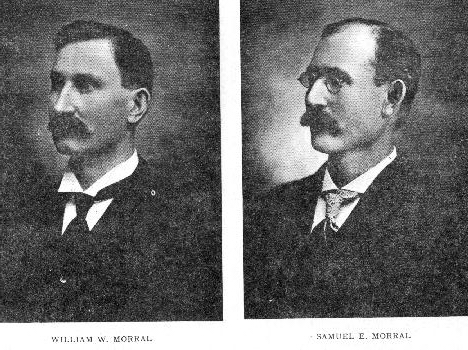
In addition to his manufacturing interests, Samuel E. Morral owns his residence in Morral and 35 acres of land, which lie within the corporate limits of Morral, and is a stockholder the Morral Banking Company, and the Morral Canning Company, the latter of which he is manager. He and his wife are charter members of the Methodist Episcopal Church of Morral. Mr. Morral is also a charter member of the Knights of Pythias lodge at Morral.
The Morral family has been identified with the improvement and growth of Morral from its earliest days, and as a whole is one of the most substantial families of the county.
http://www.heritagepursuit.com/Marion/History1907/MHM.htm
William Morral, above mentioned, was captain under General Hull during the War of 1812.

Hull's Trail was a rough passageway through Ohio to the Canadian border, used by General William Hull's army during the War of 1812 on its way to attack the English at Detroit. Woodsmen cleared the trail to permit the Ohio Army Militia with its artillery and baggage to travel through the unbroken wilderness. The route through Hardin County has been marked by stone columns from the old county courthouse.
Subscribe to:
Posts (Atom)